
Wildfire Smoke AQI - Forecasts & Maps
Wildfire Smoke AQI Forecasts & Notifications:
- No current smoke advisory is in effect
To find out more about Wildfire Smoke Advisories or Alerts, contact the District's Wildfire Response Coordinator at (707) 443-3093 x122.
Wildfire Smoke - Air Quality & AQI Forecast Maps:
- Current Air Quality Maps & AQI ***
- AirNow - Fire & Smoke Map (forecast/modeling)
- EPA AirNow (Realtime/NowCast AQI)
- Watch Duty - Wildfire Maps & Alerts
- NWS Eureka (EKA) Area Smoke Forecast
- Interagency Fire Incident Information System (InciWeb)
Interactive Smoke Maps, Modeling & Satellite Info:
- NWS Eureka Area - Daily Smoke Model Forecast ***
- NASA GOES-West NexLab/COD (satellite images) ***
- NASA GOES-West, Pacific Coast (satellite images)
- NOAA HRRR (smoke modeling)
- USFS BlueSky Daily Runs(smoke modeling)
- Nor Cal Smoke Transport & Stability Outlook (USDA)
- NASA Fire Info for Resource Mgt System (FIRMS)
- Fire Maps (NWCG Inttera)
Wildfire Smoke - Guidance, Resources & Health Impacts:
Understanding the Wildfire Forecast AQI:
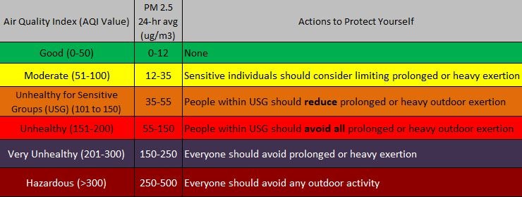
The purpose of the Air Quality Index (AQI) used in wildfire air quality forecast is to help you understand what local air quality means to your health. The AQI is divided into six categories:
The AirNow website is a multi-agency website run by EPA that reports air quality using the AQI based upon fixed air district monitoring stations. The AQI for PM on this website is a daily (midnight to midnight) 24-hour average, so hourly reporting requires a methodology called NowCast to estimate the 24-hour AQI for each hour. The reported hourly value is what AirNow calls "current air quality."
During wildfires, the NCUAQMD accesses air quality information (Particulate Matter - PM2.5) from both its existing regional air monitoring stations (that report to AirNow), in addition to portable wildfire PM2.5 air monitors (EBAMs) that have been deployed as appropriate by the District, the USFS, and CARB. The AQI forecasts that the NCUAQMD and the USFS Air Resource Advisors (ARAs) issue during wildfires (PSA, Advisories, and Alerts), are more accurate AQI forecasts for cities and regions than simply the AQI derived by AirNow that is based upon only a few fixed station monitors that are perhaps not representative of your city or neighborhood.
To find out more about Wildfire Smoke Advisories or Alerts, contact the District's Wildfire Response Coordinator at (707) 443-3093 x122.